
As I mentioned in the previous post, Big Bend Ranch State Park is the largest state park in Texas and while some of it is accessible from the scenic state highway that runs along the Rio Grande, much of the park is a bit harder to get to. I had previously been to the trails and overlooks along the state highway and I wanted to check out some of the trails in the interior of the park. One of the trails that I decided to hike was the Puerto Chilicote trail out to the West Fresno Rim overlook.
As far I can tell Puerto Chilicote means “Chilicote Door” in English, for what that’s worth. To get to the trailhead you can take a series of mostly maintained dirt roads west past the visitor center to get to the trailhead parking area. You should be able to make it here in most crossovers or even cars though the road can be a bit rough. The trail to the West Fresno Canyon Rim is an out-and-back hike of about 5 miles total that is mostly easy but involves some climbing and loose rocks toward the end. It ends at the edge of a high cliff that overlooks Fresno Canyon and the desert mountains beyond. Below is a panorama of the view from the top of the cliff.

The above panorama was a stitch of 11 vertical photos taken at about 50mm focal length. You can see a dry creek bed cutting across the canyon. I think you can get over there and drive down the creek bed to get other more remote parts of the park and camping areas, but I didn’t get over that far on this outing. Maybe next time, it looks fun.
The edges of the cliff were in the process of breaking away and falling in some parts. Looking down to the bottom of the cliff you can see the litter of portions of the cliff face that have fallen in the past. It is a 500 feet drop to the canyon floor below, so I didn’t chance my luck by getting close to these rocks but I did photograph a cactus in front of the cliff’s edge showing part of the edge that was beginning to separate. From what I read, I think this is called a Strawberry Pitaya cactus but I am not certain. I liked the way it looked against the distant canyon.

I also like the ocotillo that was growing along the cliff, though I didn’t quite get it all in the frame.

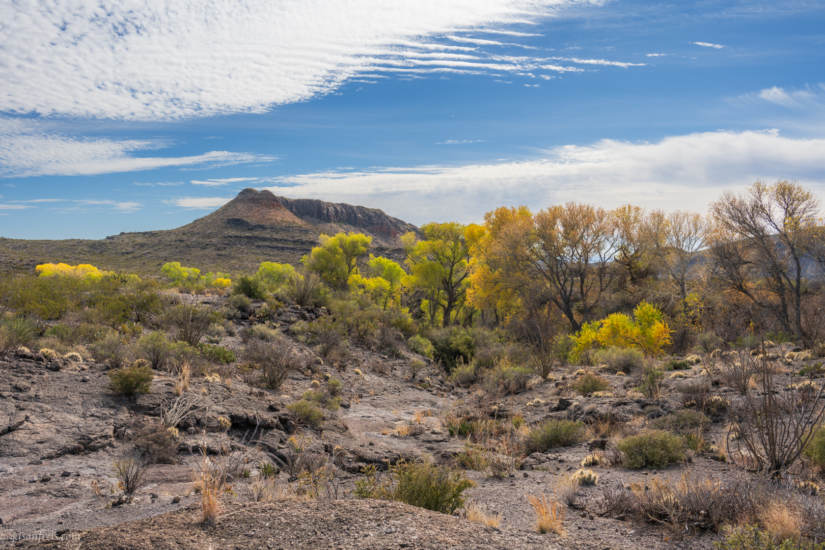
Near the beginning of the trail there was a creek bed with trees growing in it. It made a stripe of trees growing through the desert and I thought it was neat looking. I hiked around trying to see if I could find the spring or creek that was watering these trees, but I didn’t see it. Some nice fall winter color in the middle of the desert anyway.
A branch of this trail also climbs down to Mexicano Falls. I didn’t make it down the trail that far as I wanted to have time to go check out another trail. It would have been another 4 miles down the trail and 4 miles back and that would have probably finished off my day.
The other trail that I checked out was called Cinco Tinajas, but I hiked up there and didn’t even see uno tinaja. Perhaps it is too dry for the tinajas to contain water right now. I wasn’t real happy with the photos that I got on that trail, so I don’t have anything to present.
On the way home I decided to take a horrible dirt road to get to scenic highway SH170 that runs along the Rio Grande to Lajitas and then head home from there. This is a paved highway and probably one of the nicest drives in the state. There are several things to see along the river and several places to park and go jump in the water if you like. My favorite spot is an overlook at sort of a high pass from which you can look down the river toward the west. I have been here before for a dusty sunset, but I didn’t wait around for sunset on this day.

Above you can see the Rio Grande, which forms the border between the USA and Mexico. In the far right of the frame you can see the highway running down the hill and down in the shaded valley there are some people in a couple of kayaks heading down river. It’s worth the time to just drive down this highway, even if you don’t do anything in the state park.
Anyway, this is what I did with part of my Christmas break and that’s about it for my 2023 hiking and photography. I hope you have a wonderful 2024.

I love the photos, although it seems you overlooked a few things. And yes, probably a good idea to stay away from the edge.
I’ve thought of taking my wife to visit this area of Texas, so it’s nice to know there’s a scenic drive. She doesn’t hike anymore, so all she’d get out of it is what she could see from the car. She might also be able to overlook a few things.
LikeLiked by 4 people
It is a very nice scenic drive and combined with the Ross Maxwell scenic drive in the National Park it would make some nice road tripping. There are a lot of roadside overlooks and easily accessible areas along these highways.
LikeLiked by 1 person
That’s good to know.
LikeLiked by 1 person
I can highly recommend taking a trip to see the beauty of Texas.
LikeLiked by 2 people
Oh, now my hair isn’t that great.
LikeLiked by 1 person
True, but I was going to tell him to overlook that. 😂😂
LikeLiked by 1 person
Really? Who is she?
LikeLiked by 2 people
I see that you and Jason are on a roll! I will choose to overlook your comment. 😛
LikeLiked by 1 person
Aha! Good one, you punstress.
LikeLiked by 1 person
😶✋️! Nooo, I am not a punstress!
LikeLiked by 2 people
You might be. It is hard to overlook the pun you just made.
LikeLiked by 2 people
😶✋️!! Oh, help!
LikeLiked by 2 people
You sure came across as one with that last comment, or did you think I’d overlook it?
LikeLiked by 2 people
It was one of those “brilliant flashes” that I had to say …. though now I …..😶✋️!
LikeLiked by 1 person
Uh-huh. I suspect we are slowly converting you to our punny ways.
LikeLiked by 3 people
Pfffftt!
LikeLiked by 1 person
We have a really attractive armadillo that lives around here. She is a bit repelled by the smell of sugar though.
LikeLiked by 2 people
“No comment!”
LikeLike
This could explain why those who drink caramel lattes aren’t able to find any armadillos.
LikeLiked by 2 people
Or it could mean that the doolally who said they are repelled by sugar doesn’t know what they are talking about!
LikeLiked by 2 people
He drinks his coffee straight and black. As poisonous as that may be, it perks up the mind as good as any amphetamine. So I’m sure he knows what he’s talking about, even if he talks unusually fast.
LikeLiked by 2 people
Since I am from Texas and may tend to have a southern drawl, coffee speeding my speech would make me sound more like a northerner I suppose. That may be a reason to give up coffee in itself.
LikeLiked by 2 people
I understand. That could be a little risky, sounding like a damned Yankee, deep in the heart of Texas.
LikeLiked by 1 person
“Haha!”
LikeLiked by 1 person
Probably one of the best stitches I’ve seen.
Interesting area. Pulled up Google Maps… ended up burning through an hour and learning a new geological term, “loccolith”. Also some interestingly suggestive area names, and apparently a few ruins.
Good choice not to travel in an electric vehicle with a space-saver spare.
LikeLiked by 1 person
If you overlap well and don’t have a lot of foreground objects, the software usually doesn’t have a problem.
LikeLiked by 2 people
Beautiful pics even if the landscape looks a tad foreboding.
LikeLiked by 1 person
Foreboding, hmmm…. I always make sure I have lots of water with me. The landscape does make you think about such things.
LikeLiked by 2 people
That kind of harsh landscape cannot be for the faint of heart!
LikeLike
Enjoyed all the photos, especially the Fall, winter trees. 🙂 Our trees look bleak right now. I think you made a good choice to not press your luck about taking photos of the rocks. Falling down a 500 ft drop wouldn’t be fun!
LikeLiked by 1 person
The falling wouldn’t be so bad, but the landing would.
LikeLiked by 2 people
“Haha!” Yes, that would be rough.
LikeLike
Nice
LikeLiked by 1 person
Not a person to be seen in any of your photos. My kind of hiking! Gorgeous pictures.
LikeLiked by 1 person